


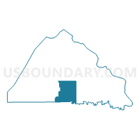
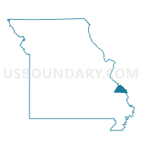
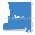
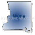
Biehle Voting District, Perry County, Missouri
About
Outline

Summary
| Unique Area Identifier | 609334 |
| Name | Biehle Voting District |
| County | Perry County |
| State | Missouri |
| Area (square miles) | 31.71 |
| Land Area (square miles) | 31.70 |
| Water Area (square miles) | 0.02 |
| % of Land Area | 99.95 |
| % of Water Area | 0.05 |
| Latitude of the Internal Point | 37.63525790 |
| Longtitude of the Internal Point | -89.82406350 |
Maps

Graphs
Select a template below for downloading or customizing gragh for Biehle Voting District, Perry County, Missouri


Neighbors
Neighoring Voting District (by Name) Neighboring Voting District on the Map
- Crosstown Voting District, Perry County, MO
- Friedheim Voting District, Cape Girardeau County, MO
- Highland Voting District, Perry County, MO
- Longtown Voting District, Perry County, MO
- P-4 Voting District, Perry County, MO
- P-5 Voting District, Perry County, MO
- Sedgewickville Voting District, Bollinger County, MO
- Uniontown Voting District, Perry County, MO
Top 10 Neighboring County Subdivision (by Population) Neighboring County Subdivision on the Map
- Central township, Perry County, MO (10,875)
- Apple Creek township, Cape Girardeau County, MO (2,100)
- Cinque Hommes township, Perry County, MO (1,403)
- Union township, Perry County, MO (1,062)
- Whitewater township, Bollinger County, MO (1,029)
- Salem township, Perry County, MO (673)
Top 10 Neighboring Place (by Population) Neighboring Place on the Map
Top 10 Neighboring Unified School District (by Population) Neighboring Unified School District on the Map
- Perry County 32 School District, MO (17,763)
- Meadow Heights R-II School District, MO (3,747)
- Oak Ridge R-VI School District, MO (2,304)
Top 10 Neighboring State Legislative District Lower Chamber (by Population) Neighboring State Legislative District Lower Chamber on the Map
- State House District 106, MO (38,873)
- State House District 157, MO (37,900)
- State House District 156, MO (34,716)
Top 10 Neighboring State Legislative District Upper Chamber (by Population) Neighboring State Legislative District Upper Chamber on the Map
Top 10 Neighboring 111th Congressional District (by Population) Neighboring 111th Congressional District on the Map
Top 10 Neighboring Census Tract (by Population) Neighboring Census Tract on the Map
- Census Tract 8801, Cape Girardeau County, MO (5,738)
- Census Tract 4702, Perry County, MO (4,820)
- Census Tract 9501, Bollinger County, MO (4,691)
- Census Tract 4705, Perry County, MO (3,829)